The purpose of this blog is to provide complete updates on trekking itinerary, detailed maps, and info on where to stay and what to expect from this 3 day high altitude trek in western Tibet as of our May 2018 Mount Kailash Trek.
But before you read the blog, revel in the mountain splendor as you watch this video:
Overall Itinerary
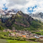
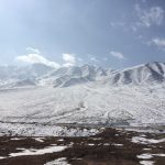
Mount Kailash is located 1,400 km almost directly west of Lhasa city (just about 20-30km directly north of the western India/Nepal border) in the Tibetan Autonomous Region. So this 3 day trek is, inevitably, part of a much longer 15-17 day journey that includes 3 days of acclimatization in Lhasa and lots of car time (expect being in the car for 4 days at 6-8 hours per day before you even reach the base of Mount Kailash). So there is lots of driving through beautiful, stark high altitude environments before you attempt trekking (and sleeping at) at 5,000 meters. This provides for plenty of great photo opps of alpine lakes and glaciers and allows sufficient time for acclimatization before you trek across the high pass of Mount Kailash, Dolma La at 5,636 meters.
A typical full itinerary might look like this:
Lhasa–> Shigatse –> Lhatse–> Saga –> Mount Kailash –> Manasarovar Lake –> Guge Kingdom–> Manasarovar Lake –> Saga –>Everest Base Camp –> Lhasa
Here is a brief overview of the entire trip to give you a better idea of the bigger picture of the trip I took in May 2018 (although you could certainly cut out Guge Kingdom and shave 2 days off your total trip):
Day 1: Arrival in Lhasa, Elevation: 3600 meters
Day 2: Lhasa guided tour, See the Potala Palace and the Jokhang Temple
Day 3: Lhasa guided tour, Sera Monastery debates
Day 4: Driving Day // Lhasa-Yamdrok Lake-Karo la Glacier-Gyantse-Shigatse, Distance: 354kms, Elevation:3840m
Day 5: Driving Day // Shigatse to Latse Distance 150kms Elevation:4200m
Day 6: Driving Day // Latse —Saga, Distance: 340Kms, Elevation: 4500m
Day 7: Driving Day // Saga To Manasarovar Lake 520kms, Elevation:5000m
Day 8-10: Kailash Trek Distance: 54kms, Max Elevation:5639m
Day 11: Darchen—Guge Distance: 254kms, Elevation: 3699m
Day 12: Driving Day //Guge—Manasarovar lake Distance: 290kms Elevation: 4597m
Day 13: Driving Day //Lake Manasarovar-Saga Distance:897kms Elevation:4500m
Day 14: Driving Day //Saga— Mount Everest Base camp Distance: 493Kms Elevation:5200m
Day 15: Driving Day //Everest Base Camp to Shigatse Distance: 350kms Elevation: 3840m
Day 16: Driving Day //Shigatse—Lhasa Distance: 260kms Elevation: 3600m
Day 17: Departure from Lhasa
Mount Kailash, 3 Day Trek Itinerary
But for the purposes of this blog, we are just going to focus on the 3 main days of the Mount Kailash trek itself.
General Information and Packing List
Every Kailash Trek begins and ends in Darchen town. While this town only has a population of around 500 local Tibetans, I was expecting only a yak hair tent with dirt floors and no running water. So the hot shower in Darchen with reasonably comfortable 3-star hotel accommodations was a big surprise and upgrade from what I was expecting.
Darchen is also called as “Tarchen” or “Taqin” in chinese pinyin. It was formerly an important sheep and yak trading post for Tibetan nomads and their herds. Until 1994, there were just 4 or 5 permanent buildings here in this town. In 1995, a medical center was founded by Swiss partners which has become a training center for doctors. After nearly 20 years of development, it now contains about 12 small restaurants (Sichuan and Tibetan food), several hotels with heat and hot water and internet, a Karaoke bar, and a Public Security Bureau for registering foreigners. In addition to that, there are a number of simple convenience stores where you can buy Snickers, water, and Instant noodles. There is not much to see here, but you can leave unneeded luggage in your hotel or in your travel agency’s car or van.
Darchen is also the place to make last minute plans for your trip including organizing pack animals (yaks or horses) from local nomads. Although you will not need to carry any tents, sleeping bags, or breakfast, lunch, dinner you will need to carry winter clothes, snacks, and water. Your day pack for the Kailash trek will probably weigh 15-20 pounds. That does not seem like a lot at first but at 5,630 meters you will be extremely fatigued and that extra 20 pounds could be excruciating for you. While a 20 pound backpack at sea level seems easy-peasy, I promise you are going to struggle over the high Dolma La pass (no matter what shape you are in) and that you would be happier to hire a yak or a human porter for the 3 days of the trek. In our group of 6 participants, the Tibetan guide along with two other members of our group ended up carrying the bags for the other 3 members of our group who were struggling. We were happy to assist our fellow travelers, but I have to say that it definitely made an already difficult trek a little less enjoyable because we were carrying two backpacks (our personal backpack on the back and another person’s on the front). Please save others and the guide in your group the added strain of having to carry your backpack up or down the high pass and just go ahead and hire a porter or a yak from the beginning. It can actually be quite difficult to arrange a yak or porter in the middle of the trek because of the remote location. So if you are going to do this (and you should) you should take care of this the night before you leave Darchen town.
Because of the altitude, I highly recommend really minimizing your gear as much as possible and considering hiring a yak or two or a porter for your group.
You can find a detailed packing list for Kailash here.
For your reference, for our 3 day trek from May 5-7, 2018, day temperatures at 10:30am at the beginning of the trek under a brilliant sun were 6 to 8 Celsius. As we set out from Darchen the weather was a little chilly with a slight breeze. As we hiked we definitely took off our layers under the bright, high altitude sun and just a single long sleeve shirt and/or a fleece was plenty warm as long as we kept moving along the trail.
This is generally the pattern in the spring and fall trekking season with relatively warm and springy conditions in the day and everything outright freezing cold once the sun goes down. We found that we got either light rain or snow every afternoon sometime between 2pm to 5pm so make sure you leave early and give yourself the better part of the morning to hike because once the afternoon comes there is a greater likelihood of meeting inclement weather.
Generally the best months to hike Kailash are May, September, and October. Before May 1 or after October 31 you are likely to encounter a good deal of snow and some of the teahouses may be closed at that time. The summer months are also okay to hike, but expect a lot of Indian tourists coming from low altitudes to hike this sacred pilgrimage and the views are also not guaranteed to be as clear to see the mountains during the summer rains.
Safety note:
There is a dirt road that parallels the kora for the first 20 km on day one and the last 10 km on day three of the trek. If something were to go wrong you could use this road for an emergency to get out but medical care is very simple in Darchen – there is is only a small clinic here. If you do decide to turn around or need a sudden evacuation you can expect to pay a premium to travel this gravel road back to Darchen town; fees to ride in a truck along this road can range from 500 to 2000 RMB just to get a lift up or down the trail for a few kilometers.
The closest medium-sized hospital from Darchen would be in Shigatse- this is 670km from Kailash.So advanced medical care is at least 14 hours away. So as you are on Kailash be mindful of the altitude and take things slow.
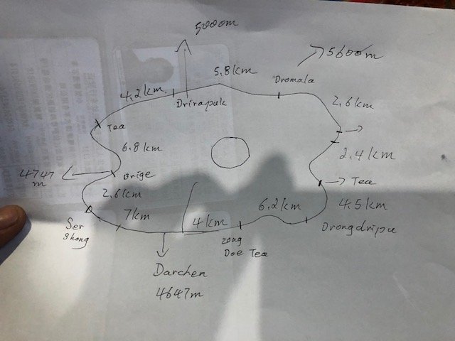
Maps for Trekking
Here are two maps that will give you the idea of the general waypoints on the trail. Note that each Tibetan guide provides slightly different measurements for the trail based on their own calculations, so there may be some small differences between the two maps, but the general idea remains the same:
Trek Day 1
Note: Below are given the times we, as a group of 6 moderately fit hikers, achieved. We had three people with us who had never hiked before in their lives and 2 of them lived in Holland at five meters below sea level. So, I’d be willing to bet that these times were on the fairly average side for most groups and, though your own times might be a few minutes off of ours depending our your pace, you will find this to be a fairly accurate estimation for your own departure and arrival times on the trail.
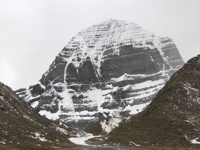
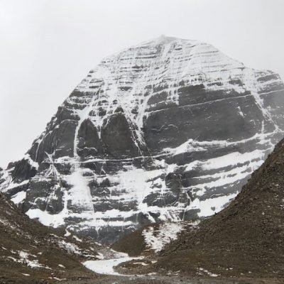
The first day of the trek will take us 20 kilometers from Darchen town around Mt. Kailash to Dira Puk Monastery (aka Drirapuk Gompa). The total elevation gain over these 20 km is 433 meters, so the trail is relatively flat for most of the day. But hiking this first day is still a lot of work as you are walking a long distance at altitude.
Today you will follow this ancient pilgrimage route with Tibetan Buddhist and Indian Hindu pilgrims. You will stay in a small guesthouse near the Dira Puk monastery. The elevation of Dira Puk Monastery is 5080 meters.
7:30am-Depart Darchen Hotel at 4,647 meters
8:00am- Start Walking from Darchen town
From the first set of prayer flags, then the next 1-2 km of trail gradually drops down and lose 100 vertical meters.
10:00am- Arrive at first view of Kailash,with prayer flags
Many of these Tibetan pilgrims do this 52 km kora in one day, leaving at 4am and returning to Darchen town at 8:00pm
Here at this first rest point, you will see pilgrims prostrating around the holy mountain. Young pilgrims will carry the clothes and goods for the elderly to a certain point and then go back and prostrate the trail themselves again. In this way they are actually doing the entire pilgrimage circuit 3 times.
For a young, healthy Tibetan, prostrating every 2 steps takes about 16 days to get around the whole mountain kora (this is a minimum for younger ones- older folks take longer.) Although there are about 8 simple teahouses on the trek that provide food and lodging, there are not enough Guesthouses for 16 days of total travel since the usual trek takes 2 nights/ 3 days. So pilgrims who are prostrating the entire trek often just sleep on the ground in warm blankets and sheep fur lined robes along the trail.
11:00am – Arrive at Serdshong Check Point (this is 7km from Darchen town). The government may check your official Tibet permits here.From this point walk another 2.6km to the first teahouse.
12:15pm- Arrive at first teahouse by bridge at 4,747 meters in altitude.
This is about the halfway point to the teahouse where we will sleep this first night.To the teahouse bridge is 9.6km from Darchen town, and it is another 11km to our sleeping destination at Dira Puk Monastery through the Lha-Chu valley.
At this first teahouse, the food offerings are very scarce. You can buy a bowl of instant noodles for 10 RMB, refill your bottle with hot water for 8 RMB, or a coke or a soft drink for 6 RMB. As you get further from civilization into the trek, these prices will go up slightly at each successive teahouse.
1:00pm- Depart first teahouse after lunch
From the first teahouse walk 6.8 km to second teahouse
From the second teahouse walk 4.2 km to the third teahouse at Dira Puk Monastery.
This is a 2 hour walk. As you approach a large bridge with prayer flags on it, you will need to ask your guide where your guesthouse is in relation to this bridge. This bridge leads to the actual Dira Puk Monastery which you can see in the distance. This is the old sight for simple guesthouses (and some groups still stay here). Our particular accommodation was in in a corrugated tin building with an all dirt floor that lay on the main trail right under the shadow of Kailash (so we stayed straight on the trail and did NOT cross left to the Dira Puk Monastery). As with most things in western China, there was construction here and this area was developing rapidly, even for being so remote. When we were there at the teahouse we saw several workers building a large 2-story concrete guesthouse which dwarfed the corrugated tin shacks and canvas tents where we were staying in size.
4:30pm – Arrive third teahouse at 5,080 meters where we will be sleeping the first night.
Note on sleeping:
Sleeping at 5,080 meters is almost as high as sleeping at Mount Everest base camp on the Tibet side. Even though your body will feel very tired, this will probably not be a great night of sleep for you because sleeping at altitude in such sheltered but primitive conditions will likely not yield a full 8 hours of rest. The simple guesthouse does provide plenty of blankets and cooked us a simple meal of hot rice and boiled egg and tomatoes.
Overall the walk on the first day is 20km and involves about 6-7 total hours of walking time (not including lunch and rest time)
Along the way there are 2 tents (teahouses) with hot water and instant noodles and these are nice places to stop to rest, refill, and get out of the bright sun and blowing winds.
Trek Day 2
The second day of our trek around Kailash will take us up and over the Dolma La Pass, the highest pass on the circuit at 5,636 meters. Although this is certainly the hardest day of the 3 day trek, excellent mountain and glacier views will follow you for most of the day. From the Dolma La Pass, you will descend to Zutul Puk Monastery (aka Dzutrulpuk Gompa on the second map), elevation 4,820 meters. The total trekking distance this day is 22 kilometers
This day you will walk 22 km total – up and down the high pass.
7:00am- Wake up at 5,080 meters in Teahouse near Dira Puk Monastery. Eat a simple breakfast of Tsampa or noodles in the teahouse.
You are going to want to have an early start because it is a long day and the snow and the wind comes in often in the afternoon, while the mornings generally have a better chance of giving clearer weather that is more comfortable for trekking.
7:30am – Depart teahouse
The road continues to be flattish with a slight incline for the first 4km of your day.
10:00am- Arrive at the last tea house before the Dolma La pass.
This is about half way to the pass. Make sure you get lots of rest and plenty of snacks here because the next 4km up to the pass is going to be the most challenging section of your whole trek, not only because you will be at the highest altitude of the whole trek but also because the last 1 hour of the trek up to the pass is the steepest trail you will encounter on the trek.
This is last place for water and snacks for another 13 km, so make sure you fill up your water bottles with hot water. You are going to need a lot of water to fight those high altitude headaches on the pass!
10:15am- Depart for high pass
The trail from the last teahouse before the pass starts out as fairly flat. Then you make a right turn at a gully and you start to go up dramatically.
About 30 minutes before the actual pass, there is a false summit of prayer flags as you go under a bunch of flags and ascend to the ridge line. I made a big push for the top thinking I only had 1 minute left to the actual pass and actually ended up wasting a lot of energy because I was still another 30 minutes from the real Dolma La Pass.
Do not make the mistake I made! When you get to this first cluster of prayer flags (that are like a little colorful cave you have to walk through and duck under) know that you are roughly at the halfway point between the sharp turn up the gully and the top of the pass.
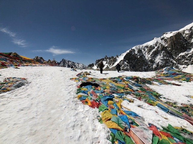
The Dolma La pass had about 1 meter of snow on the top but there was no need for crampons, Yak Trax, or boots. The snow here was consistently between 30-100 cm thick but was all trampled down by the 1000’s of pilgrims who had all walked the same path in the previous weeks. I did not posthole even once in the hard packed snow up at the top of the pass.
12:30pm- Arrive Dolma La High Pass at 5,636 meters/ 18,500 feet. Spend a few minutes celebrating and taking pictures but do not stay too long up here! Your body will definitely be wanting to descend as quickly as possible as every step down will give you that much more available oxygen!
1:00pm- Descend
The first hour of the descent from the pass is a relatively steep.
The descent is often on slippery snow and you will need to watch out for pilgrims prostrating face first down the hill. I had to step around a few pilgrims as they prostrated down the hill and it made for tricky footing on the narrow, icy trail.
You will probably want trekking poles as this is steeper than the ascent to the pass and some of the melting ice can be slippery.
2:00pm- Cross Ice river
After one hour of navigating slippery switchbacks, you finally level out more on a usual evenly- graded trail. However you have one more small obstacle before you are scott free. At the bottom of the switchbacks you have to cross an frozen river (or lake?) The body of water is frozen with several meters of ice and so it will certainly hold your weight as you walk across it’s 50 meter long ice sheet. But do be cautious here with your footing as walking on solid ice can certainly result in a pretty big fall on your butt or your side. With a backpack this ice crossing is a little unwieldy but doable if you take it slow.
From here on out, most of the trail is smooth sailing and you can make good time as you descend to a lower, more comfortable altitude.
3:00pm- Arrive at first Teahouse after the Dolma La Pass
We had a late lunch here at 5,236 meters (17,130 feet). It was a nice place to wind down from the intensity of the snow and the altitude up on the pass and I laid down here for a few minutes. As I closed my eyes I could feel the swirl of light from the bright snow stimulating my eyes behind my closed eyelids. I was very thankful I had good polarized sunglasses because I could only imagine how overstimulated my eyes would have been in the 360 degrees of bright snow without the eye protection.
This teahouse is pretty simple and only offers instant noodles and soda. While that was not exactly checking the list for all my hunger cravings, it made for a refreshing stop.
From this teahouse the trail becomes a dirt road that a car could drive on and all you have to do is put one foot in front of the other and make good time to as you hike another flat 10km slightly downhill to your sleeping destination.
6:30pm- Arrive at Zutul Puk Monastery
Get settled and sleep at Zutul Puk Monastery. This guesthouse offers a nice stone block guesthouse with cozy rooms. Our rooms did not have any heating but putting 6 people into a small room was more than enough (that combined with the ample thick blankets available) to keep us cozy throughout the night.
The guesthouse has a simple stone building with squat toilets outside and offers a little restaurant where you can eat simple bread and home made Tibetan fried noodles, french fries, and Tsampa.
Trek day 3
The third and final day of our trek will cover 10 kilometers from Zutul Puk Monastery back to the town of Darchen. After the trek, we will return for one final night along the shores of scenic Lake Manasarovar.
From Zutul Puk Monastery to Darchen the road is all down hill and flat but is long
8:30am- Breakfast – Tsampa and Tortillas with Egg at teahouse
9:00am- Depart / walk down on a dirt road
1:00pm- Arrive Darchen/ eat lunch in Darchen
2:30pm- Drive to Lake Manasarovar / 30 km
4:00pm- Arrive Lake Manasarovar / Check Into Guesthouse on Lake (has beds and blankets but no shower/ toilet is a simple concrete squatty)
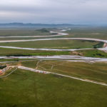
Lake Manasarovar lies at 4,590 m (15,060 ft) above sea level, a relatively high elevation for a large freshwater lake on the mostly saline lake-studded Tibetan Plateau.
Lake Manasarovar is relatively round in shape with the circumference of 88 km (54.7 mi). Its depth reaches a maximum depth of 90 m (300 ft) and its surface area is 320 km2 (123.6 sq mi). Lake Manasarovar is considered one of the 4 greatest and holiest lakes in Tibet. It is said just a single dip in the lake’s frigid waters can wipe away a lifetime of sins. It is connected to its “evil twin”, the nearby black waters of Lake Rakshastal, by the natural Ganga Chhu channel. Lake Manasarovar is near the source of the Sutlej, which is the easternmost large tributary of the Sindhu. Nearby are the sources of the Brahmaputra River, the Indus River, and the Ghaghara, an important tributary of the Ganges.
Like Mount Kailash, Lake Manasarovar offers a holy pilgrimage and this kora is 110km in length around the the lake’s shore.
You will see pilgrims prostrating around the lake against the brutal winds and fierce colds of the high altitude lake. Many of the Tibetan pilgrims, despite their naturally silky black hair, look as if their faces and hair are all totally white from weeks spent prostrating in the dirt and salty sands around the lake.
This is one of the most inhospitable places in the world yet somehow there is a lively population of shorebirds and migratory ducks that live off the insects that bury in the shore’s muddy banks.
Curiosity got the best of me and I decided to try to jump into the lake’s water for a swim. I was expecting to dive into the waters to wash off several days of dirt and stench from hiking but I found that the lake shore was very shallow and muddy. With only a water depth of around 6 inches (15cm) for the first 100 meter of shoreline, there was no choice but to plop in the mud and roll around the mucky waters. As I was traipsing around the mud I totally submerged both of my Crocs in the mud and almost lost them forever to the sucking, sinking abyss. I rooted through the icy mud for a minute and recovered my shoes but I decided it was time to get out of the soupy pool of muck on the shores of Lake Manasarovar.
After about 2 chilly, muddy minutes in the lake, I dashed onto the shore where I had stashed my clothes away from the blowing winds and as I trotted over to get some clothes on I was hit by an intense sand storm. The sand pounded right into my face and sent a terrible chill through my body. Shivering and with my heart pounding from the bitter cold, I put my clothes on and desperately ran the 200 meters back to my guesthouse to get warm and dry.
After this little excursion, I opted to go 200 meters up the road to a natural hot spring bath house. The hotspring had been piped and captured in a concrete building that offered 10 private wooden tubs with the hot spring water, so it was not exactly a totally natural outdoor experience. There were also no towels or soap provided- just a tiled room and a wooden tub full of hot water. Nonetheless, it was wonderful to wash off and get clean and this certainly made for the perfect end to days on a dusty trail and a wild Kailash trek.
7:00pm- The guesthouse on the shore ofLake Manasarovar offers a simple Tibetan restaurant and we had dinner here.
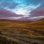
After dinner I walked along the lake shore and got some great pictures of a brilliant sunset over Lake Manasarovar. When it turned darked, I turned in for sleep in the simple concrete rooms at the guesthouse (with no running water or heat or electricity). The guesthouse was cold and there was no electricity or heat in our room but most of the clients wore 3-4 thick blankets to keep warm.
I was definitely ready to descend to a lower altitude!