I had been planning this trip for months and yet somehow it was still two days before the scheduled departure date and I still had no idea if I was going or not.
This is not the usual way I run things; usually trips are booked complete with guides, hotels, transportation months before and all the ducks are in a row. But sometimes on the high Plateau you have to be flexible. Especially when you are traveling by yourself to scout out a future trip.
The cause of the delay in this case happened to be a tiny fungus.
I had been contacting my local guide friends for months and had been asking them about going to Nyenbo Yurtse. I had seen pictures and blogs and heard that this was an epic hike amidst shark-tooth snowy mountains and crystal-blue alpine lakes and I wanted to experience this myself. So I made a plan. I would take my family here – including my 5 year old and 3 year old children. They would ride on horseback over the high pass at 15,000 feet (which is high but has a fairly gentle grade) and my wife and I would carry backpacks full of supplies.
This trip had 3 potential purposes:
1.) To have an adventure with our family
Since we had trekked to Annapurna base camp in the last years with our family in Nepal, we have wanted to take our kids out into the mountains for another go. In walking the 8-day Annapurna Sanctuary trek we had stayed in teahouses and had carried our kids on our backs in baby backpacks and the kids loved being in nature after a long time of being surrounded by concrete in a city in western China. Rose and I had started our marriage and honeymoon by walking 2,650 miles from Mexico to Canada and backpacking was a big a part of our life together and our mutual passion as a married couple. So it was naturally important for this passion for the natural world to overflow out to own kids. Now they were old enough they could get to some fairly high places, walk a little, and appreciate the wonder around them. So since that last big trek in Nepal, I had been scheming about how to get our family out. Nyenbo Yurtse seemed like a perfect way to do that. And I knew we could hire a horse and guide so it seemed like a sure fire bet to be able to bring them along.
2.) Scouting the trip for Elevated Trips
As an outdoor adventure and trekking business on the Tibetan Plateau it is my job to to get out and find some of the most off-the-track, inspiring destinations in the wilderness. I like to go to these places myself first and then look at the trip from the eyes of potential clients to see how food and lodging and logistics all can work out to make the best, highest quality trip possible. From all the rumors from local nomad friends, Nyenbo Yurtse was a must-see and offered some of the most stunning views and best trekking around. I wanted to add this trip to our offerings not only just for the clients who would come, but as another way to build bridges to local Tibetan communities to help out their local guides, horse men, hotels, and taxi drivers. As with every Elevated Trip, community impact was as high on our priority list as was serving an excellent, unique experience.
3.) It was my 36th Birthday!
I have made it a tradition to celebrate my birthday in the wilderness. Last year I went camping by myself amidst beautiful red rock gorges on a grassy mountain overlooking 14,000 foot LaJi Mountain. I wanted to celebrate and look back on my short life on this earth by enjoying it untouched beauty. And it just so happened that the weather forecast looked pretty good for June 6!
So I had good reasons for going. And I had dates set in motion. The only problem was that I had been contacting my local guide friends in the area and none of them could seem to be able to book in a horse guide. This was an essential part of the plan to be able to get my kids over the high pass because there was no way these kids were going to be able to walk 30km over 3 days in the mountains on their own two feet. I sent several phone calls and emails and never heard anything back from my local contacts.
Then it got to be about a month before the expected departure on June 2 and I still had no guides or pack horses definitely lined up. So I called my guide friend again and he said, “Sorry. I just can’t find any guides for you right now. They are all out in the grasslands picking caterpillar fungus.” I asked many other foreign and local friends with connections around Nyenbo Yurtse and they echoed the same reply. EVERYONE from middle school students to middle aged dads was out in a money-making caterpillar fungus CRAZE!
But first let me explain. Caterpillar fungus, known as Ophiocordyceps sinensis, is considered by wealthy Chinese as an important traditional Chinese medicine, especially as an aphrodisiac. O. sinensis parasitizes larvae (aka caterpillars) of the ghost moth family and then germinates in the larvae, kills and mummifies it, and produces a fruiting body that is like a tiny stick that emerges from the corpse and stands upright, poking like a tiny pencil tip a few centimeters out of the ground. The fungus is ground into a tea or powder and taken either as pill or is drank as a tea. This fungus parasitizes a specific species of high altitude caterpillar that is almost only exclusively found in the Himalayas at altitudes primarily between 3,000 to 5,000 meters in the mountains and so Tibetans and Nepalese mountain villages have a good corner on the production.
Tibetans call the caterpillar fungus “Yartsa Gunbu” and in rural Tibetan economies with few sources of income besides yak and sheep, this is a very big deal. In rural Tibet, the fungi contributed to 40% of the annual cash income to local households and 8.5% to the entire GDP in 2004- and the market has been growing quickly since that figure 13 years ago. In 2008, one kilogram of caterpillar fungus sold for between $3,000 USD (for the lowest quality specimens) to $18,000 USD (for the best quality larvae). These days in 2017, a kilogram could sell for as much as $75,000 USD in the upper end of consumer markets in Beijing or Shanghai.
Needless to say: Caterpillar fungus is big money for often marginalized communities. So every May and June schools and businesses close for a month or so and every Tibetan nomad and their mother and their kids are all out looking for this treasure. In a day, a single nomad might scour 20-40 pieces of this fungus and could easily make $300 USD selling it to traders in their community. That is one person over one day. Multiple those numbers by entire villages, families, and communities over a month and they start to add up. Some Tibetans tell me that they make 80-90% of their entire yearly income in just a period of 30 days by picking huge amounts of this fungus from the
rich pasturelands of their yaks.
Given the incredible (and very strange) economic boom of caterpillar fungus, it is no mystery that not a single horse guide could be found at this time for me. Every single Tibetan horseman would consider my usually generous standard guide fee as small potatoes compared to the money he and his family could make by digging up the fungus. If I had been looking for a guide in July or August or September this would not have been a problem. But in late May and early June, It was like trying to find a needle in a haystack. And so, after about 20 phone calls, emails, texts to a multitude of friends, I was sitting two days before the trek without a horse guide. I had held out hope we would find a horse guide but now it was crunch time. And this meant things were not looking too good for my family to go trekking in Nyenbo Yurtse.
I talked it over with my wife. We had been traveling a lot and had just spent 2 months in about 6 different states in America. She said she would like a break from traveling but she gave me her blessing in being able to do the trip myself.
So I made a last minute decision.
After months of planning the itinerary as a family trip, I would go to Nyenbo Yurtse myself. If I had to I knew I could carry my own 40 pound backpack if there were no guides to be found. So I called my friend, Phil, and asked if he was up for a last-minute adventure to hike Nyenbo Yurtse. We gave Google Earth a search and we looked at the trail and the mountains and figured at least the first half along the alpine lake looked straight forward (after that we were not exactly sure which pass we were supposed to cross but figured between us we could ask someone in the trailhead mountain town to figure it out along the way).
His wife, amazingly, said he could go and we set the departure time for June 2 morning. We did not even have the departure time or confirmation of going until around June 1.
This was probably the most last minute trip I have ever been on. I packed and we set off on June 2 morning.
This is the route we took and this is exactly how I would recommend getting there to and from Xining.
June 2, Day 1
Xining – Labrang
We drove 239km from Xining, the capital of Qinghai Province to Labrang in Gansu Province (Xiahe in Chinese) over 5 hours. In Xining we started out at 2,300 meters and worked our way up to 2,900 meters in elevation in Labrang. This drive, just a few years ago, used to take 8-10 hours to navigate horribly muddy and pot-holed roads (and the trucks broken down in the muddy pits along them) that were especially difficult to drive after crossing the bridge over from Qinghai to Gansu Province. However, now there is a raised highway between Xining and Rebkong (TongRen in Chinese), which is roughly the halfway point to Labrang. This section from Xining to Rebkong is very fast with multiple newly built tunnels that run for a few kilometers directly through mountains and now only takes about 2.5 hours and offers excellent views of the emerald waters of the Yellow River.
June 3, Day 2
Labrang – Maqu
Once in the heart of the Gansu grasslands in Labrang we continued south another 103km, or 2.5 hours, to Luqu, another small town in the grasslands. Luqu offers little in terms of interest for visitors but has some nice noodle shops and makes a good lunch stop along the way for hand-pulled noodles.
After Luqu we continued another 80 km, or 2 hours, south to Maqu. The town of Maqu is seated right on one of the first bends of the Yellow River and we visited a small monastery with about 100 monks just 2 km north of Maqu town. The monastery is quite small and we found there was not very much going on in terms of activity in the monastery but was still interesting to explore the mud-daubed houses of the monks as well as the main temple hall. The highlight for us in this monastery was walking to the top of the hill where the former monastery ruins were and looking down on the town and the large bends of the Yellow River as it winded in and out of the grasslands below us with very dramatic twisting curves for as far as the eye could see. The monastery outside of Maqu is 3,600 meters in elevation while the town itself, as a central region of the Golok Tibetan tribe, is around 3,500 meters.
June 4, Day 3
Maqu – Jigdril
We left Maqu in the morning after a nice Tibetan breakfast of yoghurt and Tsampa and drove for our last and final stint of 5 hours to Jigdril (Jiuzhi in Chinese). After two days of good driving on well paved roads, we were in for some harder driving today as we crossed over the Yellow River two times. The drive from Maqu to Jigdril turned out to be only about 4 hours, but 2 hours of this time was spent going 20km/hour or less on very bumpy dirt roads. These roads will likely be fully paved in the next two years but until then, this is a backcountry road that is under repair and, in wet conditions, it would be best to have a good 4WD vehicle to navigate some of the longer sections of inches-deep mud and potholes.
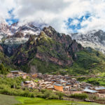
We arrived in Jigdril in early in the afternoon. Jigdril town, at 3630 meters, is the on Qinghai side of the border of Sichuan and Qinghai Province. From here it is only 75km to the south to the town of Ngawa in Aba Prefecture in Sichuan Province. If one were to drive from Chengdu, rather than Xining, you could drive from Chengdu to Barkam, Barkam to Ngawa, and then Ngawa to Jigdril over 3 days. Jigdril County, one of the 6 counties of the Golok Autonomous Prefecture, has an average elevation of 3,800 meters and is most famous for the incredible peaks of Nyenbo Yurtse National Park.
Once we settled into our hotel, we hiked up from the main street of Jigdril and crossed the local river outside of town to gain about 200 meters in elevation to get a better view of the town. It was a great warm up hike and from here we got our first views of the Nyenbo Yurtse mountains, hovering just 50km from Jigdril town. The rain and fog cleared just as we crested the grassy hill and the peaks of Nyenbo Yurtse, now covered in fresh snow were gleaming against the blue sky and then new rays of sun. I was getting my first views of the mountain and I was getting very excited!
June 5, Day 4
Day one of the trek
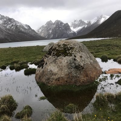
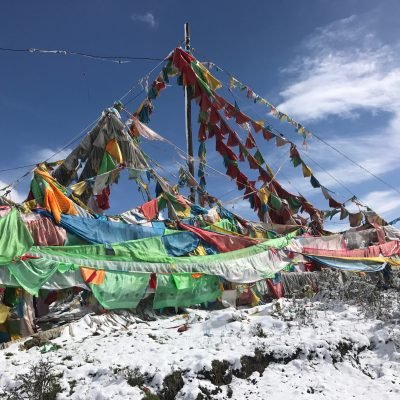
We had a quick breakfast of dumplings and tea eggs at a local restaurant and got a taxi to drive us to the Nyenbo Yurtse trailhead. The drive took about 1 hour from Jigdril town (which cost us 150 RMB for a one way trip in a local taxi) and took us over two spectacular high passes, both filled with prayer flags set against new fallen snow. AT the the entrance of Nyenbo Yurtse National Park, we paid 120 RMB per person for our entrance tickets. There is a boardwalk here with a few Chinese tourists, but most of these don’t venture more than a few hundred meters into the park. The trek starts on this boardwalk and winds to the the left of the the alpine lake. The trek starts at 4,026 meters and for the entire 10 km of the first day of the hike, you maintain this elevation as you walk for 6km along the lower alpine Shuntso Lake shore and then another 2.5km along the upper Shuntso Lake that flows into the lower lake.
In our case we actually walked on the path to the right of the lower lake because it had just been raining for 3 days straight and the trail to the left of the lake (usually the one used by trekkers) was said to be very mucky and slippery by our horse guide. There is actually a circular pilgrimage (and thus good trail) around the whole lower lake. So this was no problem. However, in walking the path to the right of the lake we came to the small river where the upper lake flows into the lower lake. We had to take our shoes off and wade up to our knees across about 20 meters of fairly shallow, icy water to cross to the main trail. This was not a problem for us but I imagine this is why most trekkers start on the left, rather than the right, side of the lake.
From the very first moment the hike is stunning. On most hikes you have to gain a few hundred meters and hike 10km or so before you get into the really spectacular scenery. But as soon as you step into the park, there are huge rugged peaks right before your eyes tucked right behind the shores of the turquoise alpine lakes. This hike is very unique because you gain zero total elevation on the first day and yet have incredible views and rewards all the way. Even if I had not done the three day trek, I still would have made the 3-day, fifteen hour drive down to the park AND paid the high park entrance fee, just to spend one day around the lower shores of lower Shuntso Lake.
It is absolutely fantastic to walk along the shores of lower Shuntso Lake and listen to the waves gently lapping against the beach shores with an incredible backdrop of dramatic cliffs. It makes for a very relaxing and wonderful hike and there is no sudden uphill to shock your system into the wilderness on this first day.
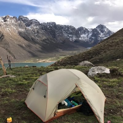
After 10 km of walking along the lower and upper lakes camp at upper Shuntso Lakes we arrived at the top of the upper lake and made our camp here. It was very windy here and as soon as we arrived a snow storm blew in. We scrambled to set up our tents quickly in the hail and the snow. Within 20 minutes the storm blew through and the sun was reappearing again to reveal an incredible snowy mountain behind our camp against a bright, clear blue sky.
At our Camp 1, we cooked dinner, made a small fire from some scrubby bushes along the lake and went to bed after a very satisfying first day in the mountains.
June 6, Day 5
Day two of the trek
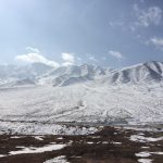
Departing the upper lake from Camp 1, we ascended 200 meters over a gently sloping sheep trail about 3km over a small pass that was tucked back and to the left of the valley we slept in. From the top of this pass you curve in left enter a large boulder field with scattered truck-sized boulders that are littered throughout an alpine grassland. The trail then flattens out a bit for 1km and you walk further back into a gorgeous alpine valley with sharply pointed peaks all around you. Once you walk into the heart of this valley there are two very clear passes (both of which had snow on them as of June 6) as the valley floor splits into a “Y”. Take the path as it leads to the left and continue to ascend this pass via a sheep trail. I inquired about the pass on the right of the valley and our guide said it was both too steep and too snowy to cross and front the looks of it I fully agreed with his assessment.
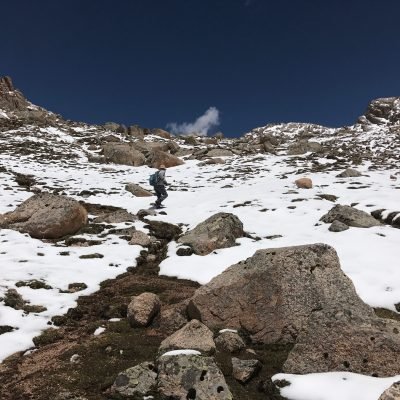
From this “Y” in the valley – this is where the hike got quite challenging. We would now ascend the final 300 meters to the high pass over about 1 km.
This is the steepest and most difficult part of the whole hike. The trail rises at about a 7% grade up into the snow-covered, rocky pass through 2 “false summits”. While this grade is not, in itself, particularly steep or dangerous, it is enough of an incline that it gets the heart beating at such a high altitude climbing from 4,200 meters to 4,500 meters. This is where we were especially glad that we had hired a pack horse and horse guide. Getting up the pass was difficult work with a day pack and I can only imagine how tough it would have been with a full, 40 pound backpack full of a tent, food, and sleeping equipment.
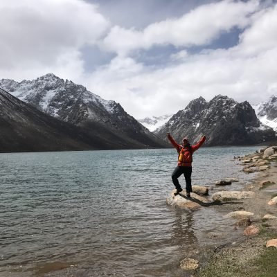
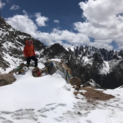
Today was also my 36th birthday and I could not think of a better to have spent it! It was absolutely one of the most spectacular things I had ever seen. Crossing the high pass in ankle deep snow was exhilarating. The sun was bright and we could look down the valley to several towering spires, each shooting off the main ridge of the mountain like an arm sticking upright into the cold, clear air.
The high pass was higher than any point in the entire 48 United States and all but the 5 highest peaks in all of Europe. The weather could not have been more perfect. Up here it would be very easy to get snow or rain but we were bathed in the warm sun and could see in all directions.
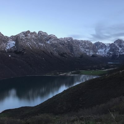
From the prayer flags and the yak skull on the pass we descended another 4km to our tent site on an upper slope of a third alpine lake. This is where we made Camp 2 at around 4,100 meters.
From here, at this nomad camp, we had an incredible sunset over the mountains with reflections glimmering below in the 7km crystal blue alpine lake. This was a great tent site and we enjoyed a dinner of warm pasta with our Tibetan guides after a long and epic day walking across the pass.
June 7, Day 6
Day three of the trek
We woke up in the morning and descended over 4 hours about 12km past the last lake to a small cement road in the back end of Nyenbo Yurtse National Park. We had arranged a 2pm pick up with our previous taxi driver and I think I hit the parking lot at exactly 2pm – so that was pretty good estimation as far as timing.
Coming down off the mountain and skirting this last and longest lake of the hike, I felt excited and energized. I was like a horse heading home to the stable. I was ready for a good warm meal, a hot shower, and clean cotton sheets and now I was only a few kilometers from finishing the trek. I barely stopped, except for a few times to take pictures. The trail was flat or downhill and the views of the long lake were invigorating. I got a good deal ahead of my friends in my excitement and arrived at the outflow of the final lake at least 30 minutes before them. I laid on the grass overlooking the lake under the heat of the high altitude sun and took in the last three days of hiking now behind me. Given the good weather (and the fact that no one else was around) I decided to take a quick naked swim in the lake. The blue color of the lake was just so inviting that I couldn’t pass up this opportunity to finish the trek off with a cool dip!
I gingerly walked with my bare feet over shrubs and sharp rocks along the shore, found a small beachfront, and dived into the chilling water! I was probably only in the water less than 20 seconds! It was all direct melt from the nearby glaciers and it was some of the coldest water I had ever been in. I think it was just about the same temperature as Guitar Lake at the base of Mount Whitney in the Sierra Nevadas of California – at least from my memory of that freezing experience!
I rushed out of the lake and let the sun evaporate the cool water droplets off my body. Just as I was exiting the lake, I saw my friends turn the corner of the trail and approach me. They had caught up much quicker than I had anticipated – just soon enough to catch glimpses of me shimmering and diving into the frigid waters. Inevitably at least one of my friends took a picture of me swimming for good measure.
I put my clothes back on, ate a terrific picnic lunch on the shore, and we set off for the last few kilometers of our hike. We could now view the cement road in the distance and it seemed like only a stone’s throw away. We were practically home! I figured this was going to be easy-peasy!
But, as I arrived in the parking lot, I was totally spent. My high energy and enthusiasm from hours before had waned significantly. Now I was baked in the sun and felt like I was walking away from one of my high school wrestling matches – having left every ounce of energy in the arena. The sun and the work finally caught up to me and my legs were starting to feel quite tired and a little shaky.
Another reason for my exhaustion was because of the terrain in the last section. I had just spent the last 1.5 hours traversing a wetlands marsh and hopping from grass clump to grass clump to try to keep from plunging into the soggy mud that surrounded the Nyenbo Yurtse river basin. The high amounts of precipitation that fell in the week previous to our trek had left this latter trailhead an alpine bog as the little streams flowing into the larger river had swelled and overflowed into all the surrounding grasslands. The whole ecosystem below my feet had become one interconnected swamp; when I stepped on one part of the grasslands, the whole thing tumbled and shook in other parts sending a ripple effect throughout the whole rooted, soggy mass. There were times I had to walk 100 meters off course just to find a place where I wouldn’t sink too deeply into the mud. It was all a good deal of mental work for what I thought would have been flat, easy walk.
After passing a nomad herding his yaks along the river bank, I hopped from one tiny tufted island to the next, each just about 1- 1.5 meters apart, sometimes almost not making the connection due to the slippery, squishy mud. But, I finally made it to the parking lot by 2pm and laid down on my backpack. It felt good not to be walking anymore
We paid our horse guide and exchanged contact information. He was now going to do the entire 3 day trek in reverse (in less than one day’s time) to return to his family tent in the next valley and to continue his labors to find and pick the treasured caterpillar fungus.
As for me – I was tired but felt well rewarded. The Nyenbo Yurtse trek had been a truly enthralling birthday event and I could think of few other times in my life when I had felt so alive and so joyful. Despite the mud and the hard work, it had been so worthwhile to do the trek and I couldn’t stop scrolling through my pictures because it was almost hard to believe that I had really been in such a beautiful place with perfect weather. Now it was back to the hotel in Jigdril for a night of rest!
This was definitely one of my best birthdays to date!
June 8, Day 7
Jigdril – Henan
This was the long drive day. I had driven to Nyenbo Yurtse in 3 days and we were heading back to Xining in 2 days. This meant a 10- hour driving day through incredible grasslands (particularly famous for their high quality, fresh yak yoghurt).
The road took us back into Gansu Province and then winded off to a newly paved road back into Qinghai Province. Throughout the journey, I picked up a few different hitch-hiking nomads. I had an extra seat in our car and I figured they did not want to walk back home another 25km in the rain.
We stopped for the night in Henan town in Qinghai Province. This was a slightly surreal Mongolian resettlement town in the middle of nowhere. The buildings were all made in the cheap-concrete communist fashion that is so endemic to most grasslands communities on the Plateau. But each building- looking like it was crumbling and falling down after only a few years of use- bore some characteristically Mongolian symbols, especially the blue and white eternal knot and other interlaced motifs. All the signs bore 4 different languages: Mongolian, Tibetan, Chinese, and English. The English, or “Chinglish” was a real highlight. I couldn’t find a single storefront sign that made 100% of sense. Most were just badly translated attempts at English phrases form technology that had not caught up to its place in time just yet.
Some of the real winners were…
(note that as I type them are VERBATIM as they actually appeared):
“dongxiang shouzhu pasta museum” (actually just a hole in the wall noodle shop – not a full blown museum 🙂
“He zhou delicious steamde dumpings restaurant” (I think this was supposed to be a dumpling joint)
“Kodak electrical appliance supermarket” (a tiny store that had nothing to do with photography but instead sold horse bridles and plumbing supplies)
“I can I show shoes shop” (probably self explanatory)
“Macro blue department store” (a 7-11 type store that sold plastic balls made in a factory in Guangzhou)
“Casserole yang jia ma la tang” (a Muslim restaurant that sold chicken head soup)
“Snow mountain sand negative” (I never actually figured out what this store was actually selling).
“Global Mobile Square” (a cell phone store that sold knock offs of Apple iPhones)
“Convenience of parity vegetable shop” (Obviously just a vegetable shop with a convenience of parity)
“Shining Underwear” (an underwear shop with a catchy name)
And my personal favorite:
the “Virture Fort Burger” (some rip off of a rip off of a rip off of Kentucky Friend Chicken)
June 9, Day 8
Henan – Xining
Today we drove drove 5 hours from Henan town back to Xining. Our route took us through the nomadic trading towns of Zeku and Rebkong. After Zeku we dropped down from a pass through some very scenic landscapes with forests, rivers, and old Tibetan towns.
Along the way I stopped at high pass in the grasslands and spent about 20 minutes hiking up to a cluster of prayer flags flapping in the wind high over the local villages.
We returned to Xining by late afternoon and after the long drive it was nice to be back home!
Summarizing comments
Overall, I can’t highly recommend the Nyenbo Yurtse enough as a trek. The drive and journey there is incredible, although the last 150 km of road getting to Jigdril is quite slow and bumpy along very muddy and bumpy roads, but that is part of what keeps this destination so well-preserved and off the map of the conventional Chinese tour bus routes.
As far as season, we had incredible weather on June 5,6,7 for our 3 day trek. I had decided to go in the first week of June to avoid both the rainy season and higher rates of Chinese tourists that travel to Nyenbo Yurtse National park in the summer months of July and early August. This was a great decision in terms of weather and having almost the entire national park to ourselves. Once we got past the first 100 meters of the first alpine lake at the park entrance, we only saw a few local nomads out picking caterpillar fungus in their own home turf.
However, I can’t recommend traveling to Nyenbo Yurtse as a trekking destination in early June because, as you have seen, that is the high caterpillar fungus season and it was very difficult for us to find a horse and horse guide who were able to carry our backpacks for us up the mountain. Ultimately, the trek could be done without a horse to pack in our backpacks but I think this would have significantly made the high altitude ascent extremely exhausting and would have taken away a lot from the enjoyment of the beauty. I think most people would have a great struggle to carry their own tent, food, and clothing up a 4,596 meter high pass. The trail is probably never more than a 7-8% grade in slope, but the last 3 km leading to the high pass are very fatiguing because of the lower available levels of oxygen and the continual upward slope.
For the best season I would recommend trekking Nyenbo Yurtse in late August (when some of the Chinese tourists have returned to their big cities) or in early September, when the weather is chilly but likely clear.
I think it is very reasonable to follow my same route in taking 3 days to get to the trailhead, 3 days for actual trekking, and 2 days to return to Xining or Chengdu.
Note on registration in hotels in Maqu, Jigdril, and Henan towns
As of early June 2017, foreigners are allowed to stay in these restricted areas but have to sleep in very specific hotels in town that are registered with the police to be able to officially host foreign passport holders. These are the same hotels that we used on our trip.
Do not be surprised if the police personally come visit your hotel room or need to check and copy your passport in these areas. In Jigdril, police came into our hotel room at 9pm at night just to check our belongings and register our passports. In Henan, we actually had to make copies of our passports and drive to the police station across town to register.
In these restricted places, it is very common to be asked to register in such a manner. This bridge in relationships, along with the obvious route finding help on the Nyenbo Yurtse trail, is one great reason I recommend using a local Tibetan guide along this journey (as we at Elevated Trips always do) so that these procedural encounters with the local police are smooth and easily managed.
To book this trek of a lifetime in Tibet: