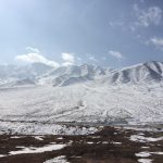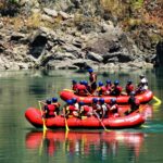
Above is a video of Nangchen as seen from the air by drone footage. This footage is a rare glimpse into this wild land that has seen few foreigners.
See the wildest parts of the Tibetan Plateau with us as we trek Nangchen’s biggest mountains:
Introduction to Nangchen
Nangqên County is a place that is as diverse as the many spellings of its name. This place, known both as Nangchen (Tibetan: ནང་ཆེན་རྫོང་།) and as Nangqian County (simplified Chinese: 囊谦县; pinyin: Nángqiān Xiàn), is a county of the Yushu Tibetan Autonomous Prefecture and is the southernmost county-level division of Qinghai Province in western China. Nangchen famously borders the Tibet Autonomous Region to the south and many parts of Nangqian County are only a 30km drive from this border, neighboring the Tibetan Chamdo district. But don’t get too excited. Foreigners would need a very special permission to cross this particular border so most travelers will have to be content to stay in Qinghai Province. But if you don’t mind the bumpy roads and burly terrain, travelers will find they could spend at least 1-2 weeks in this region with no problem. And, unlike the Tibetan Autonomous Region, you do not need any special permits to travel here. Making this land a wonderland for adventurers and free spirits alike.
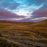
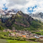
The county seat is called Xangda (Chinese: 香达镇), and lies in a fertile high altitude valley on the right bank of the Dza Chu (a branch of the upper reaches of the Mekong River). Today the total population of Xangda (also called Nangchen town) sits right around 60,415, and 98% of this population are ethnically Tibetan. Geographically, Nangqian County is one of the least inhabited regions of the Tibetan Plateau with a small population spread across a total surface area of 11,539 km2 (4,455 sq mi). Today Nangchen, like many Tibetan towns, is growing and developing quickly as new hotels and paved roads replace the old dirty guesthouses and the potholed, bumpy dirt roads that mark this as a western outpost of civilization before one reaches the border of the Tibet Autonomous Region or TAR. But for now this is still a pretty remote town that is largely isolated by giant mountains and gaping rivers. Nangchen is definitely not a luxury destination, so don’t expect more than a few 3 star hotels or simple guesthouses. But do expect to be absolutely amazed by the grandiose scenery and lots of wildlife. As home to Himalayan Golden Monkeys, Blue Sheep, Wild Ass, and Tibetan Antelope, Nangchen is a nature lover’s paradise. There are no hotels outside Nangchen town so be prepared to travel with a local guide and stay in very simple home stays or tent stays (we are happy to help you arrange these if you need some local contacts). Outside of the town, all the roads are mostly dirt and there is very little in the way of running water, flush toilets, or good internet. But this is a great chance to get away from all the noise and electronic buzzing to really engage local Tibetan nomadic life and learn to live like yak herder in the mountains.
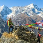
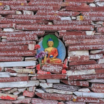
For having such a relatively sparse nomadic population the Nangchen area has one of the largest ratios of monasteries to people. The second thing you will notice about driving outside of Nangchen town (after you experience the jaw dropping cliffs and steep granite spires) will probably be that you are in the middle of nowhere (often with no electricity and running water) and yet every 5-10km is a giant Tibetan Buddhist monastery. This is a spiritually devout land whose origins and culture run as pure and deep as it’s expansive gorges.
Getting To and From Nangchen
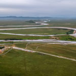
Nangchen is usually accessed through the Tibetan town of Yushu 玉树. Xangda (aka Nangchen town, but also called Sharda in Tibetan) is located 193km south from Yushu (Jyekundo) via the Ke La Pass, 160km from Zurmang Dutsitil and 189km from Riwoche. Most travelers will need to either fly into Yushu Batang Airport (YUS) or will need to start their travels from Xining. From Xining it is a 800km (12 hour) drive down to Yushu and then from Yushu it is another 3.5 hours drive to Nangchen. 100% of both of these road sections is completely paved so the driving is quite good. But the distances mean that you will need to budget at least 8 days for your travel time to adequately see Yushu and Nangchen. This is such an expansive land that you will want 2-3 days to drive from Xining to Yushu, 2 days to acclimatize to altitude in Yushu, and then another 4-6 days to travel around Nangchen and really see what this land has to offer. And remember that most of the places in and around Nangchen are between 4,000 to 4,500 meters so make sure you take your time to get here and spend plenty of time properly acclimatizing. For more on how to prepare for high altitude see here. So if you only have 3-4 days in total to travel, you probably want to consider a destination that is closer to Xining, maybe Qinghai Lake, Rebkong, or Kanbula National Park.
Travel Information and Destinations in Nangchen
Here is some recent insightful travel information from a fellow traveler, Kerrie, who visited Nangchen in Summer 2019.
“If anyone is planning to travel to Nangchen DO NOT use this website as a guide. Most of the information is incorrect.
https://www.lonelyplanet.com/c
From the places I’ve been here is some more travel information:
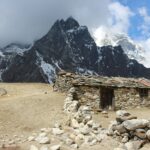
Gar Monastery (aka Gar Gompa)
Gar Gompa is a 90min to 2 hour drive south of Nangchen through grasslands and a forested river valley.
The standard taxi fare is 350 RMB one way, but you may be able to bargain and/or get the driver to stop at smaller monasteries along the way. I ended up seeing one small monastery, about 10km outside Nangchen and an old (and this year, disused) salt farm too.
Garden monastery
This day trip is also 350 RMB one way. Whilst it’s not that far from Nangchen in terms of distance – its about 60km, around the same as Gar but in a different direction – the bumpy road goes over a high mountain pass. so it’s around a 2-3hour drive from Nanchen. Garden monastery looks like it’s on an island as it’s situated on the bend of the river.
Dana Monastery
This would make a great 2 day/ 1 night excursion from Nangchen. It is a 650 RMB one way drive from Nangchen. A 3 1/2-4 hour drive from Nangchen. There’s a hot springs and a nunnery nearby.
Summary of Gar Monastery, Garden Monastery, and Dana Monastery
One really cool thing about the mountain top monasteries is that they almost all have roads to the top. There’s not that much to see in the actual monasteries themselves. I think people go to see the views from there and for the journeys to/from them, as the surrounding countryside is both stunning beautiful and very varied.
Gar Monastery has a yak butter sculpture exhibit which was closed at the time of our visit and a nice if very short kora walk. Garden Monastery has a few old buildings. Dana Monastery has a small hall dedicated to King Gesar and a large stupa containing some of his relics.
Gar has a great view of the surrounding mountains and grassland, and Garden and Dana have nice views of the river. Apparently you can walk to the meditation huts (high up the mountain…) at Dana monastery but we didn’t have time.
The timings above for driving are all a bit vague as we stopped a few times on the way. The road to Gar Monastery is good, and the 1st 50km or so of the road to Dana monastery is good too, but after that you are looking at narrow concrete roads or gravel/dirt tracks over high mountain passes. The weather can change very quickly (we drove through a hail storm and a thunderstorm – in different places… – on the way back yesterday) and you can get stuck behind slow moving trucks so you don’t really know how long the journey will really take. Muddy and/ or gravel roads can become treacherous too. The middle part of the road towards Dana monastery has landslides everywhere. We drove past 3 bulldozers pushing debris down the mountainside.
If you go to Dana monastery, there is a small mountain top monastery about 60km along the route (we couldn’t stop but now I wish we had.) My driver didn’t know the name, but I’ve seen it in photos.
If you are really lucky you may find other foreign travelers in Nangchen to share the car with, but don’t expect to as very few people seem to travel alone here. In fact, very few people travel here at all whether in groups or not. You may also find a taxi driver who is willing to take you there and back for the single fare. Taxis aren’t cheap but the few drivers I asked about hiring a car all wanted 1000 RMB per day or 500 RMB for half a day minimum. The taxi worked out cheaper overall.”
History of Nanchen
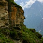
Historically, Nangchen was one of the five kingdoms of the historical region of Kham (Eastern Tibet). Nangchen was spared from the onslaught of Gushri Khan’s armies in the 17th century, mainly due to the nomadic lifestyle of its inhabitants and the harsh, inhospitable terrain that made this region difficult to occupy and settle. There are only a few areas flat enough for cultivation in Nangqian County and most of these are in the flood plain of the Mekong River or its tributaries. Against the backdrop of vast grasslands, dramatic limestone and sandstone cliffs and immaculate nature reserves, Nangchen is one of the most interesting and uncontaminated parts of Kham. There are about 78 monasteries in Nangchen. In these monasteries there are famous living Buddha’s and great teachers and many pilgrims come from over 100km to pay holy homage to these revered Buddhist sages.
A Brief Background Of Kham Tibet (Eastern Tibet)
Amdo and Kham are generally considered to be the two Tibetan ‘provinces’ that made up Eastern Tibet. These areas have largely fall into the provinces of Qinghai, Sichuan, and Gansu in western China. The Amdo region now forms a part of these three present-day provinces – the bulk of Qinghai, the southwestern edge of Gansu and the northernmost grassland of Sichuan. The western part of Kham consists more or less of what is now the Chamdo district of Tibetan Autonomous Region, while the northern Kham region lies in Qinghai’s Yushu Prefecture, its southernmost part is in Sichuan’s Muli, and Yunnan’s Dechen (Chi. Deqing or Zhongdian).
The region of Kham was traditionally known by local Tibetans as Chuzhi Gangdruk, i.e. ‘Four Rivers and Six Ranges’.
The four rivers of the “Four Rivers and Six Ranges” are:
- The Salween (Tibetan:.Ngul-chu, Chinese:.Nu jiang)
- The Mekong (Tibetan: Da-chu, Chinese: Lancang-jiang)
- The Yangtze (Tibetan: Dri-chu, Chinese: Chang jiang)
- And the Yarlong (Tibetan: Dza-chu/Nya-chu, Chinese: Yalong-jiang).
The six highland ranges which form the watersheds for these river systems are as follows:
- Tsawagang range (5100-6700m) which includes the fabled snow peaks and glaciers of Mount Kawa Karpo (6702m) and which lies between the Salween and the Mekong
- The Markhamgang range (Chinese: Ningjing Shan 5100-5700m) which lies between the Mekong and the Yangtze
- The Zelmogang range (4800-5400m) between the northern reaches of Yangtze and Yarlong
- The Poborgang range (4800-5600m) lies between the southern Yangtze and the lower Yarlong
- The Mardzagang (5100-5700m) occupying the area between the upper Yalong and the Yellow River
- And lastly the Minyak Rabgang range (4800-7750m) including Mount Minyak Gangkar (7756m), the highest mountain in Kham, which lies between the lower Yalong and the Gyarong.
Since the disintegration of the Tibetan Yarlung Dynasty following the death of King Langdarma (the infamous king who destroyed Buddhism in the 10th century), the kingdoms and tribal confederations of Kham, whether nomadic or sedentary, have- until the last century – aggressively maintained their independence from Lhasa and were always at war with each other. This has meant that the region of Kham Tibet maintains its own very individual identity from the more affluent citizens of Lhasa. These are cowboys and men who live in the high mountains who walk with swagger. The Kham people are kind and curious yet they have survived some of the harshest wind and snow storms to cross the harsh Tibetan Plateau.
In recent history, the most important states in Kham were the five kingdoms of Chakla, Derge, Lingtsang, Nangchen and Lhathok, ruled by a series of hereditary kings (in Tibetan these kings were called “gyalpo”).
Today, the 47 counties of Kham are included in the four provinces or regions that include the Tibet Autonomous Region, Yunnan , Qinghai and Sichuan Province. And Nangchen lies at the heart of Qinghai’s Kham nomads.